Jeranism pointed me to a recent N/S circumnavigation so I started thinking along those lines and found this wonderful little film.
↧
North South circumnavigation by PanAm in 1977
↧
Amateur video logs of Antarctica workers might lead to clues.
↧
↧
U.S. Navy 30 min 1967 documentary on Antarctic & possible clues
As of April 8, 2016, today, I only found this newsreel from 1967 made by the U.S. Navy. I'll review it in coming days with an ear and eye trained on anomalies consistent with our suspicion that Antarctica is a rim that's 60,000 miles in diamter-- not "an island at the bottom of the world" that is 15,000 miles around. Other paths I'm taking include personal video diaries of Antarctic workers and amateur vlogs of flights to and from various research stations. In these, I'll be listening and watching for any indication of trips between research stations to compare time and distance in reality vs. what is consistent with either flat or spherical earth. I'll watch for those infamous Inspection Tours-- of which none seem to have been conducted in many years-- possibly 10 years. Anyway, I'll be enjoying the following Navy production over coming hours and days and invite you to join me over popcorn as I continue my virtual circumnavigation of Antarctica. Trump made a very fast and inexplicable reference to Antarctica several months ago. I wish I had noted that here when it happened. Now I'll have to look for it.
↧
1903 isotherm map with early explorer's routes is interesting.
I've looked a fair number of maps of Antarctica so when I point out how unique and interesting any one particular map is, you can be assured that my choice is based on some fair judgement. I'll study the following map more closely in coming weeks but I wanted to post it now for my readers. I noted that the easiest lines to follow are the winter and summer isotherm lines. Interestingly, in my view, those isotherm lines would be the ideal routes for an ship's expedition to take to prove 15K or 60K.
![]()

sources
http://www.bing.com/images/search?q=Large+Map+Antarctica&view=detailv2&&id=EB2270E9F9F32A872E6EA576673E90598688D3C9&selectedIndex=61&ccid=FpPegDny&simid=608054932115555254&thid=OIP.M1693de8039f2123d537e4649b40f5e9ao0&ajaxhist=0
http://www.ebay.com/sch/sis.html?_nkw=A1+large+poster+MAP+ANTARCTICA+GERMAN+SOUTH+POLE+ICE+CAPS+ATLAS&_itemId=251019204620&_trksid=p2047675.m4099
http://www.ebay.com/itm/1903-ANTARCTICA-SOUTH-POLE-SOUTH-SHETLAND-ISLANDS-Antique-Map-Dated-/111942107147?hash=item1a1045000b
↧
Swiss Polar Institute's (SPI) 90 Day "Antarctic Circumpolar Expedition" (ACE) Dec.20,2016 to Mar. 18, 2017 financed by billionnaire Frederik Paulsen will prove flat earth 60,000 mile rim vs. 15,000 perimeter
Last night, while browsing using various search terms, I found this...

I'll add more to this blog entry over coming hours and days. My discovery of this mission fits right into this blog's purpose. If the earth is indeed flat as many of us think, then we must moniter the Swiss Polar Institute voyage very very carefully.
This trip will be much more important than those Vendee Races which I've had a very difficult time verifying because the SPI mission touches several verifiable points on three continents and consists of one mission with a lot of publicity coming up-- whereas the Vendee races are very sketchy with no reference points any of us third party observers can independently verify. This trip is also now more important than the Antarctica Treaty Inspection Tours-- NONE of which completely toured via a complete circumnavigation of most important research stations in one tour. I tried very hard to look for blogs to independently verify distances and times from station to station but it became a tangled mess and mass of data I couldn't make sense of. Historical trips like Cook's are too far distant in the past-- and historical routes were too non-circumferential to be able to make sense of given my time for analysis.
THIS SPI tour thus becomes THE single most important reference point for the "flat earth community" to look at now. I have not yet contacted anyone in that community about my discovery of this importance. This very blog post will be my connection to them in that regard starting now. This is it. Ab Irato features my latest entires on his Fakeologist.com blog so I expect some exposure there to begin with along with search engine exposure under keywords antarctica and circumnavigation. Jungle Surfer gets a lot of exposure on his Youtubes for fake events and he's looked at Antarctica circumnavigations recently-- being the humorous observer he is-- but he came to no definitive conclusion. I would suggest that he and Ab follow my very close tracking of this particular Swiss Polar Institute mission as they're able. This should prove once and for all, one way or the other, if Earth is a ball or disc.
Virtual Captain Rick says--- I looked up the ship that will make this journey-- the "Akademik Tryoshnikov" named after a famous Russian adventurer Tryoshnikov and found a short Youtube video of it's launch. From there, I found several more impressive Youtubes of the Tryoshnikov ship so I created a playlist of those I viewed or partially viewed enough to recommend to my-- now hundreds of readers per post-- here. I know my readers will enjoy this unique playlist as much as I did because THIS is "the" ship that has a chance to prove, once and for all, if earth is flat or spherical-- by virtue of its planned journey and time of journey-- via a path I determined to be of such consequence that I zeroed in on this "test" once I understood the flat earth proposition. Enjoy the videos. I'll post more to this blog entry in coming days to follow up. -Thursday night, 10:20 MST Phoenix AZ, April 18, 2016.
Virtual Captain Rick's Log - Friday, April 29, 2016, 6 am MST Arizona.
After viewing the impressive launch of the Akademik Tryoshnikov in the video playlist above, I'm ready to join the crew via the internet to circumnavigate Antarctica. As a virtual stowaway on this boat, with the proposed scientific mission of proving the earth flat or global, I don't expect to be treated fairly by the crew or the organizers. I've gathered many email addresses of persons officially connected with the voyage but haven't yet contacted anyone concerning my particular project.
My first thought this morning, as I began thinking on this again, was the compete lack of contact with any of the many Antarctic research stations on the coast of Antarctica. What an odd situation! I would suppose that this lack of contact, given the fact that this is a scientific mission, and that that research stations are too engaged in science, is the first anomaly that I would point to as indicative of a possible problem. As I mulled this problem over, I thought I would transpose the voyage's route, as seen in the first map above, onto my rough flat-earth map with research stations placed on it--- the very first map in the world like it-- which has recieved hundreds of hits since I posted it. The voyage of the Akadmik Tryoshnikov is seen as a red dotted line blow.
 |
| The route of the Akademik Tryoshnikov, to take place Dec. 20 2016 to March 18, 2017 is seen above as a dotted red line. The orange dots are major research stations. The trip begins in South Africa and goes to Australian, from there to South America and then back again to South Africa-- counter clockwise on the above map. WHAT AN ODD ROUTE this scientific mission has planned for itself! The closest it comes to making a stop at any Antarctic research station is south of Australia near Scott and McMurdo. The complete avoidance of McMurdo is especially troubling in this regard since that station is the biggest and most advanced Antarctic station of all, sponsored by the usA. Examining the first map above again, it appears most of the trip is plotted north of the Antarctic Circle-- a possible clue as to what sort of "permission" was granted to the Tryoshnikov and the Swiss Polar Institute. It only appears to dip below the Antarctica Circle-- possible militarily protected area due to the possible flat earth secret-- from Australia to South America, north of the Unclaimed Territory. |

Update Fri., April 29, 2016 3 pm MST Arizona by Rick
The Akademik Troyoshnikov begins its circumnavigation of Antarctica Dec. 20, more than seven months from now-- which gives us lots of time to consider the parameters of what we need to see to confirm a round or flat earth. After reviewing its planned route, I'm not happy with its complete avoidance of all the research stations. Docking at the research stations would have enabled us to confirm time and distance easily since all the stations have newsletters and would have reported the visit of the Troyoshnikov. We could have confirmed times and speeds and thus mileage without much trouble. As it is, it will not dock at any of the stations although it may come close to McMurdo as seen on the maps above.
ICEBREAKER? I'm not sure if the Troyoshnikov is considered an ice breaker. I would think that it would have to be although it does take a route that approximates the sailboats of the alleged Vendee Race circumnavigations-- and those sailboats are certainly not ice breakers.
ROUTE? The planned route of the Troyoshnikov seems to be well north of the Antarctic Circle-- possibly north of 60 deg. south except for one stretch between Australia and South America, north of the Unclaimed Territory. A spherical earth distance would be between the equatorial diameter of 25,000 miles and the said Antarctica diameter of about 15,000 miles.... likely 20,000 miles. A flat earth distance should be closer to 60,000 miles although well north of that would be less-- potentially quite a bit less-- at around 40,000 miles. So in this case, we're stuck with comparing a 20,000 mile trip with a 40,000 mile trip in terms of rough order of magnitude. That 2:1 ratio is not as definitive as the 4:1 ratio we'd have by comparing a 60,000 mile trip to a 15,000 mile trip-- which would be the case if we were visiting all the research stations. The 2:1 ratio is still useful-- but not nearly as exciting.
Virtual Captain's Log - Friday April 29, 2016 - 7:14 pm MST Phoenix AZ.
I've had 35 hits on this new blog entry so far. I've had over 1,000 hits on some of my entries. I feel a responsibility to my readers. I want to get this right. I can feel the struggle to think harder and better against my declining energy and mental powers. I want to do the math involved but I can't. Too many details. It should be easy to determine a 60,000 mile rim vs. a 15,000 mile shoreline but it's not. This latest discovery of a Swiss voyage has captured my interest but even there-- the essence of the problem gets fuzzy because they do not plan to stop at any of the research stations. Yet the Swiss voyage is a scientific mission with stated goals similar to the research stations.
I dropped the ball on my station-to-station virtual voyage. I don't know when it happened or how it happened. I don't have time or energy to review all my entries. My project is now bigger than even I can recall for myself. I don't know my own plan. I don't know my own past with regards to my own mission. I'm an amnesiac since I have to leave the project to tend to daily life and it takes time to refresh my own memory of my own path on this journey.
Here's a formal description of the Swiss project I found. This PDF file has the most detailed map of the route of the voyage I've yet found.
https://www.mio.univ-amu.fr/IMG/pdf/ace_callforproposals-1.pdf

Notice that this particular map at this site... https://www.mio.univ-amu.fr -- does not refer to the 1st, 2nd and 3rd leg as the simplified map I first found does. This map details the visit days and cruise days, however... which is far more useful. I cannot find a LIST of the locations as seen on this map-- which would have been helpful. I might have to make my own list. There is no clearly stated starting point on this map as on the simplified route map. There is another map I found that clearly labels the starting point as Cape Town, South Africa on Dec. 20, 2016.

The first destination is labelled as "Marion/Prince Edward (SA)". There are no coordinates of latitude and longitude listed so I'm forced to find them for myself. The position of Cape Town seems to be west of the Prime Meridian 0 degrees.... It looks to be about 25 degrees West Longitude and about 40 deg. South Latitude. There is a code label on Marion/Prince Edward "ZAF". That might be an airport code, I'm not sure . Cape Town is also labeled ZAF. I'm not familiar at all with Marion Island.

Rick's Update, 6 am, Sat. April 30, 2016 from Phoenix AZ.
"ANTARCTIC CIRCUMNAVIGATION EXPEDITION" is the label assigned to the project, with the clever acryonym "ACE". I've never seen that acronymn done before although it could be attached to any mission that goes around Antarctica. If you google the key-words, you'll get results pertaining to the SWISS POLAR INSTITUTE (a newly formed organization funded by pharmaceutical giant FERRING PHARMACEUTICALS headed by Frederik Paulsen JR., whose father started FERRING around 1946 and who died around 1997 when JUNIOR took over. All the articles about this trip emphasize the environmental research and the public service nature of it but I suspect that FERRING PHARMACEUTICALS are hunting for new molecules to develop new products.

Google search - "antarctic cirumnavigation expedition" - Google Search
http://www.google.com/search?client=safari&rls=en&q=%22antarctic+cirumnavigation+expedition%22&ie=UTF-8&oe=UTF-8
FORUM-- I'm going to be using the forum for gathering data on this and other related topics from now on. It's linked at the top of this page... and here.
Antarctica-- Continent or Rim?
http://www.network54.com/Forum/764333
http://www.network54.com/Forum/764333
- SWISS RESEARCH TRIP - Business Insider article View Thread - Rick on Apr 30, 2016
- "SWISS POLAR INSTITUTE" newly created-- ? article in EPFL journal - Rick on Apr 30, 2016
- First stop - Prince Edward / Marion Islands-- WIKI descipt. etc. - Rick on Apr 30, 2016
- EPFL 32 page PDF file with photos - official document - Rick on Apr 30, 2016
- ACE - "Antarctic Circumnavigation Expedition" - google search - Rick on Apr 30, 2016
Update. Sunday May 1, 2016. 7 am MST Phoenix AZ by Rick P.
There is apparently one man behind this mission: Frederick Paulsen Jr., president of Ferring Pharmaceuticals. This voyage is his. As it turns out, he has been "adventuring" for some time now and has been interested in the "poles". That's food for thought. Check this out-- the blurb that promotes a book about his adventures:

End of quote-- Rick continues...
VIKINGS DISAPPEARED. One would have to be familiar with the mythical disappearance of the Vikings into a "hollow Earth" to appreciate the significance of Paulsen's interest in his childhood dreams sparked by Viking tales of his native Sweden. One would also have to understand that in the "hollow Earth theory", there is no north pole-- and therefore Paulsen could not have "stood at the North Pole". I would expect that if Paulsen went toward the north from Sweden, that he would have seen that a gyroscope would indicate an increasingly angled descent into a hole. Apparently, according to him, there is no hole. Fine. As a flat earth researcher, I can accept that for now. The book he wrote, cited above, must however recount the hollow earth theory and Viking disappearance into it if it is to be complete. Paulsen MAY have confirmed that there IS NO HOLE at the North Pole.
PAULSEN HIMSELF BECOMES MORE IMPORTANT THAN HIS CURRENT MISSION by virtue of the fact that he is an adventurer himself interested in a bigger picture-- from childhood. The current mission of the Tryoshnikov ship on its circumnavigation of Antarctica is too far north to satisfy a determination of a 60,000 mile Antarctic rim but Paulsen's overall interest in "all the poles" and the Vikings lends itself to opening up the possibility that, as an ADVENTURER, he MAY be interested in proving the Earth as spherical or flat by confirming a tighter-to-the-shoreline-Antarctic-circumnavigation as being 60,000 or 15,000 miles. The current mission could be a pilot program with that determination in mind. He may be "testing" the security of the Antarctic Circle and the military presence there under the cover of an ecological and environmental mission for his own protection. He would certainly have had to have interacted with Antarctica Treaty authorities to approach Antarctica near McMurdo as the route above shows. He may be able to use this experience to plan a second mission closer to the Antarctic shoreline in the future.

Frank Paulsen
References
1. Wikipedia entry.
https://en.wikipedia.org/wiki/Frederik_Paulsen_Jr
2. Ferring Pharmaceuticals
http://www.ferring.com/en/home/
3. Paulsen's book-- Chasing the Cold -- is available at Amazon.
http://www.amazon.com/Chasing-Cold-Frederik-Paulsens-Quest/dp/2916552626
4. Institute of Marine Science article provided an interesting route map. Note the distance scale in the lower left. All distance scales I've seen on all maps of the route, like this one, indicate distances consistent with a spherical Earth. If Earth is flat, those scales are wrong of course. That's why an actual mission or a multitude of blog entries about going from station to station are required-- to expose the possible lie about the scale distance.

http://www.icm.csic.es/en/sorpasso-research-project-will-study-ocean-atmosphere-exchanges-during-antarctic-circumnavigation
Update. Sun. May 1, 2016. 8:30 am MST Arizona by Rick P.
I'd like to compare the last inspection tour I know of-- in 2006-- with Paulsen's circumnavigation. Here's the google search....
https://www.google.com/search?q=antarctica+inspection+tour+2006&btnG=Search&num=100&newwindow=1&safe=off&hl=en&gl=us&authuser=0
quote from U.S. Antarctic Treaty Inspection 2006
http://2001-2009.state.gov/g/oes/rls/or/2006/77652.htm
The U.S. inspection team arrived in the Antarctic Treaty area (everything South of 60 degrees South latitude, on November 14, having departed Punta Arenas, Argentina, on November 12, 2006 on the National Science Foundation ship M/V Laurence M. Gould. The Inspection Team inspected the following stations: Rothera (U.K.), O'Higgins ( Chile ), German Receiving Station at O'Higgins ( Germany ), Esperanza ( Argentina ), Bellingshausen ( Russian Federation ) and Great Wall ( China ). The Team inspected the following vessels, with the permission of the masters of each: M/S National Geographic Endeavour, M/S Lyubov Orlova, M/S Explorer II. The team also visited the U.S. science field camp at Petermann Island to review how tour operators would comply with site guidelines agreed by the Treaty Parties regarding that area, and U.S. 's Palmer Station. The Inspection Team returned to Punta Arenas on December 1, 2006.

Rick says--
Look at how short this inspection tour is in terms of the route! It was only a 2 week tour. The inspection was led by the U.S. State Department which interestingly was under Hillary Clinton at the time I think. It's interesting that it's the State Dept. that conducts these missions! Who would have thought that? The National Science Foundation and Raytheon are also involved in inspections as seen from the following inspection "checklist"....
https://www.nsf.gov/about/contracting/rfqs/support_ant/docs/gen_management/treatychecklist.pdf
Update by Rick, Sunday May 1, 2016 @ 9:45 MST Phoenix AZ
It strikes me that Belleny Island to Thurston/Peter Island will be the most interesting part of the voyage from a flat earth theory point of view. That's because that stretch is south of 60, the Antarctica Circle, the border of the Antarctica Treaty. Furthermore, the crew apparently stops at Scott Base-- the only research station stop-- Scott being an island and south of the Antarctic Circle controlled by the Antarctic Treaty. None of the Vendee Race sailboats go this far south as far as I can recall.

The following particular map-- from an official source I'll find later-- has a route that goes directly from Marquarie Island to Balleny Island, which completely avoids the South Magnetic Pole-- which Paulsen says he's been to before. That's a bit odd considering that this is a full science mission. You would think with his previous experience and interest, he would send this crew to that point again for further testing. Note too, on this map, that the ship does NOT go to the Mertz area BEFORE Balleny. (See the map above where it DOES). That's an anomaly I'll look into.


Here wee see a route map that includes Mertz which Felix has pointed out to be an iceberg (in the comments below). Notice how close the ship comes to South Magnetic Pole.
Now notice how that that leg of the trip-- from either the South Magntic Pole & Mertz OR... Ballemy & Scott.... to Peter Island toward the peninsule, takes place over 4 sets of longitude lines. If you count all the way around the circle, you'll find 12 longitude lines, for 360 degrees or 30 degrees per line on this map. This is all based on the original sumerian math of base 60, or the sexagesimal system of counting. My point here is that the sub-Antarctic Circle portion of the trip is indeed south of 60, inside the legal Antarctic Treaty Zone-- of presume military defense of flat earth knowledge-- and is as close as one can expect to the landmass of Antarctica given the icebergs and ice in the water. And it covers 4 lines amounting to 4/12 or 1/3 of the way around-- qualifying as a true PARTIAL circumnavigation of Antarcica. If it's a rim, and if it's 60,000 miles all the way around, then 1/3 of that is 20,000 miles. The cruise days are noted as 1.3, 6.1 and 3.1 along that stretch or roughly 11 days... less than two weeks. (see map with times above). There are no DATES as such.
That's roughly 20,000/10 = 2,000 miles a day on a flat earth and 1/4 of that on a spherical earth with Antarctica being an island on that sphere--- for 500 miles per day. Captain James Cook posted 200 miles a day in his log book I think, according to Eric Dubay (I'd have to double check that-- but I'm just roughing this out in order-of-magnitude right now from memory). It's concievable that today's best ice breakers from Russia can more than double the speed of Cook's sailing ship. Still, it seems like quite a bit. That's 500 miles a day! In a ship! On the ice! Near ice flows! According to their PLAN! If Earth is flat, the 2000 miles should take an equivalant 44 days or almost 2 months. If we cut the speed in half, that's 3 months. If we triple that for a complete circumnavigation on a flat earth, that's almost a year-- which is in the order of magnitude I would expect. As it is, I do NOT believe that the Tryoshnikov can run 500 miles a day between Ballemy and Peter 1st Island for 11 days which is what they SAY they will do no a spherical Earth with Antarctica being an island. We would have to monitor their stops at Belleny, Scott and Peter 1st Island as well as Diego Ramirez to verify their trip. The rest of the trip isn't as important as this leg because it's all well north of 60 and requires different numbers entirely-- still interesting but not nearly as interesting as the sub-60 leg.
The only way that they can get from Balleny to Diego on a flat earth, covering 2000 miles a day south of 60 latitude is if there is a secret military naval support system that can install jet engines on this boat to rocket it, south of 60, across 120 degrees of latitude in 11 days at about 100 mph. That way they can create the illusion that the ship covered that distance in the allotted time.

Update by Rick on Sunday afternoon in Phoenix, May 1, 2016.
SOUTH OF 60
Felix pointed out that the Troyoshnikov - or Treshnikov-- is scheduled to visit Mertz Glacier and he linked an article to it about another expedition that visited it a few years ago.
http://www.niwa.co.nz/news/niwas-tangaroa-sets-sail-to-study-how-antarctica-affects-ocean-currents
In the context of what I'm interested in, I pointed out to Felix that the Mertz trip (on some maps and not others of the Treshnikov route)-- is the first time that the Treshnikov dips below 60 deg. S... the Antarctica Circle-- which falls under Antarctic Treaty Law. This is significant. It might be the key to this whole thing.
The first time that the expedition will turn south and cross the 60 degree south latitude line is a critical turn because they will cross into a new ocean-- an ocean only created in the year 2000. Here's a traditional spherical earth map of that area.

Southern Ocean: The ocean bordering Antarctica and extending from 60 degrees latitude soutwards. This fifth ocean was recognized by the International Hydrographic Organization in the spring of 2000
reference: Policy Options: Message in a bottle
http://www.gdrc.org/oceans/southern-ocean.html
British vessels are not supposed to sail into Antarctic waters without permission from the relevant department in the Foreign and Commonwealth Office. See the FCO website for more information. Penalties are very severe if this ruling is not observed.
http://iaato.org/advance-notification
www.explorersweb.com/oceans/news.php?id=19981
Mar 1, 2011 ... Skip Novak has 24 years of experience in sailing in Antarctica. To his ... and in some countrys cases, even individuals must apply for permission to enter Antarctic Treaty territory, defined by any movement south of 60 degrees.
To CIRCUMNAVIGATE, Paulsen must have permission from that nation claiming territory--- north of 60?
Any vessel intending to visit Antarctica must obtain written permission from its national authority responsible for the implementation of the Antarctic Treaty and Protocol.
The Antarctic guidelines do not apply north of 60°S. However, those territories which are north of 60°S in the Southern Ocean are under the jurisdiction of their respective national governments and are dealt with on their specific Noonsite pages. The relevant authority should be contacted before visiting any Southern Ocean Island to ascertain the latest regulations and restrictions.
Rick says... so the Southern Ocean goes north of 60 and involves the nation claiming that part of the antarctica pie?
This is getting complicated.
PERMISSION REQUIRED TO SAIL SOUTH OF 60
www.noonsite.com/Countries/Antarctica?rc=Formalities
All expeditions to Antarctica south of 60°S must obtain permission from the national ... A zarpe will be issued for sailing in Chilean Antarctic waters and one must ...
All expeditions to Antarctica south of 60°S must obtain permission from the national Antarctic operator or the relevant government department (See Documents section below). Until recently yachts arriving without permission were tolerated, but this is no longer the case.
http://www.noonsite.com/Countries/Antarctica?rc=Formalities
Rick says-- I have not seen any reference to permission for sailing south of 60 in any of the PDF's or articles about this Swiss Circumnavigation sponsored by Frederik Paulsen.
Rick says-- Apparently, tourist boats CAN visit bases!
If wishing to visit a base, the base commander should be contacted first by VHF (Channels 12 or 16) to request permissi
http://www.noonsite.com/Countries/Antarctica?rc=Formalities
Update by Rick on Sunday afternoon in Phoenix, Sat. May 6, 7 am MST 2016.
SOUTH OF 60 Part II
Rick says-- Earlier I noted that the Mertz Glacier trip is the first time that the A.Trishnikov will voyage south of 60 south but this morning, upon taking a closer look, a map of their route shows them going to Macquarie Island south of New Zealand first, at 54 south.
Some cut and paste references & links....
https://www.google.com/search?q=macquarie+island&btnG=Search&num=100&newwindow=1&safe=off&hl=en&gl=us&authuser=0
https://en.wikipedia.org/wiki/Macquarie_Island
Macquarie Island lies in the southwest Pacific Ocean, about half-way between New Zealand and Antarctica, at 54° 30' S, 158° 57' E. Politically a part of
Macquarie Island
Island in the Pacific Ocean
Macquarie Island lies in the southwest Pacific Ocean, about half-way between New Zealand and Antarctica, at 54° 30' S, 158° 57' E. Politically a part of Tasmania, Australia, since 1900, it became ... Wikipedia
Area: 49.36 mi²
Elevation: 1,345′
UNESCO World Heritage Site inscription: 1997
Since 1948 the Australian Antarctic Division (AAD) has maintained a permanent base, the Macquarie Island Station, on the isthmus at the northern end of the island at the foot of Wireless Hill. The population of the base, the island's only human inhabitants, usually varies from 20 to 40 people over the year. A heliport is located near the base.
Rick says--
In my survey of all the Antarctica research stations, I don't recall going to the Maquarie base. I seem to have missed it entirely. The station is significant as far as Antarctica research stations go. It looks beautful to me. Lots of tundra greenery.
From Wikipedia
quote
In 1890, New South Wales transferred the island to Tasmania,[5] which leased it to Joseph Hatch (1837–1928) between 1902 and 1920 for his oil industry based on harvesting penguins.
unquote
https://en.wikipedia.org/wiki/Macquarie_Island
Rick says-- Wow! You can harvest penguins for oil? I don't think I've really understood this before now. I've encountered WHALE OIL settlements from the 1800's but not PENGUIN oil... though I've wondered why settlements didn't EAT penquin meat. And check this out--- beautiful weather above freezing all year with "crisp" year round stable temperatures.
Climate[edit]
Macquarie Island's climate is moderated by the sea, and all months have an average temperature above freezing although snow is common between June and October and may even occur in Macquarie Island's "summer".

https://books.google.com/books?isbn=0521266335
Patricia Selkirk, Rod Seppelt, David Selkirk - 1990 - Nature
Today there is no permanent snow on Macquarie Island, one of few subantarctic islands without it. South Georgia rises to 2934 m. Heard Island to 2745 m, lles ...
http://www.antarctica.gov.au/webcams/macquarie-island
http://www.antarctica.gov.au/living-and-working/stations/macquarie-island/living
http://www.bing.com/images/search?q=macquarie+island&go=Submit&qs=n&form=QBILPG&pq=macquarie+isla&sc=0-0&sp=-1&sk=

PERMISSION REQUIRED TO VISIT MACQUARIE ISLAND
https://books.google.com/books?isbn=0521266335
Patricia Selkirk, Rod Seppelt, David Selkirk - 1990 - Nature
Macquarie Island, a small subantarctic island, is politically part of the ... We are grateful to the Macquarie Island Advisory Committee for permission to visit and .
https://books.google.com/books?id=jcSqZTMMHEIC&pg=PR13&lpg=PR13&dq=macquarie+island+permission&source=bl&ots=j7bsPHAdc4&sig=5xmbpX26Hn6NPRwJBlQe6OnEANY&hl=en&sa=X&ved=0ahUKEwik3eGfksjMAhXBLyYKHQNkC-4Q6AEIHzAC#v=onepage&q=macquarie%20island%20permission&f=false

Sat., May 7, 2016
Today, I continue to consider the Swiss ACE trip to Macquerie island-- the first time the Russian ship turns south to go beyond 60 degrees south.... a significant line defined legally as being the Southern Ocean and thus requiring permission from the Antarctic Treaty people. If the earth is flat and Antarctica is a rim, not an island, then this crossing is their "defense line" for maintaining the myth.
I googled....
www.aph.gov.au/.../House_of_representatives_Committees?url...
(AAD) of logistic support for activities on Macquarie island. TASMANIA'S ROLE AS THE .... a staging and resupply base. Permission to visit Macquarie Island for.

Rick says... So UTasmania seems to be a place where we can upset the undergrad apple cart and point to the problem of flat earth.

Rick says... so the hotels in Christchurch would be a great place to talk to people in the bars and lounges about flat earth proof. It's theoretically possible to rendezvous with the crew of the Swiss expedition when they get there.
www.usatoday.com/story/cruiselog/2013/...islands/2611955/
Aug 2, 2013 ...Access to the area is generally limited. ... The 20-day itinerary includes visits to Macquarie Island, the only place with royal penguins; Campbell ...
TASMANIA
Update by Rick P. Sunday May 8, 2016 7 am MST.
It appears that due to Macquerie Island's proximity as a unique lush location with plenty of wildlife, south of 60 and thus inside the Antarctic Treaty Zone, that Tasmania, the closest civilized area, is doing quite a bit to exert control over the situation. The University of Tasmania promotes the fact that they have the world's only Antarctica Faculty. When I visited their website, however, I could not find the names of any professors, students or researchers I could contact. Widening out from the University itself, I decided to look at Tasmania in general and found that Hobart, the capital city is a useful reference point for looking into Antarctica as a rim, not an island.
Search on tasmania + antarctica yields useful results.
Source:
http://www.antarctictasmania.com/
Quote:
Antarctic Tasmania | Antarctic Tasmania
With its ideal location as a staging post for Antarctic voyagers, Hobart, Tasmania's capital city has had connections to Antarctic exploration extending back to 1773. Today Hobart is not only the hub of Australia’s Antarctic program but is home to a range of national and international Antarctic and Southern Ocean organisations and is a world-class centre for Antarctic and Southern Ocean education and research.
Hobart has developed some unique capacities to support people and organisations with interests in Antarctica and the Southern Ocean. The Tasmanian Polar Network, an organisation with over 60 members, can provide a huge range of specialist goods and services for any Antarctic voyage or activity.


Rick says... Note that Hobart is only a few hours north of the shores of Antarctica with nothing but ice... yet Hobart is relatively lush. Same thing with the Maquerie Island. You have to wonder why there is such a start contrast in such a short distance. This opens up more questions regarding how the sun moves and what Antarctica actually is.
Rick says.. The http://www.antarctictasmania.com/ website continues with the following...
quote
With its range of scientific organisations and international secretariats Hobart is an ideal location for meetings or forums.
unquote
Rick says... This looks more promising than any Antarctica related activity in either South Africa, or Southern Chile and Argentina or even the Antarctica Peninsula with it's numerous research stations-- all off limits to regular civilians. I began this blog by looking at towns in southern Argentina but they were not geared for anything as academic as Hobart. Hobart is THE place to be for FLAT EARTH / ANTARCTICA RIM research, in my view-- this morning. It even beats anything in New Zealand or anywhere else in Australia. It now appears that the Swiss ACE trip is "missing the boat" by not steering for Hobart as PART OF THEIR JOURNEY!!! ... at least to provide a "conference" opportunity for all the Antarctica students there. This MIGHT BE AN INDICATOR that the trip is "fake"-- as many things are in Antarctica "exploration" these days-- like the Vendee races or the runs to the South Pole by individuals.
quote
Tasmania's Antarctic cultural heritage, events and attractions and significant community of people who share a passion for the Antarctic continent reinforces the city's Antarctic ambience. Stand on the docks at Hobart looking south and the next landmass is Antarctica.
unquote
source: same as above
quote
Tasmania’s Antarctic community makes a significant cultural and social contribution to Tasmania. The Tasmanian Government through Antarctic Tasmania continues to build the capability of the Antarctic community, maximise opportunities for continued growth and support endeavours to improve the management and understanding of Antarctic and Southern Ocean ecosystems. It also works to strengthen and promote Tasmania’s Antarctic cultural heritage.
Antarctic Tasmania is the contact point for all businesses and organisations whose activities will help to achieve these goals.
unquote
Rick says.... Given this being the case--- that they regard themselves as the contact point for all businesses and organisations, then why would the Swiss ACExpedition fail to make contact with Tasmania Antarctica? They're so close, but fail to make that step.
http://www.antarctictasmania.com/home/international_conferences_and_meetings
Rick's Note-- This blog entry will now end and I'll pick it up in further entries. I'm off-track a bit with Tasmania and will seek to get back on track with the circumnavigation in the next entry.
↧
↧
Maquarie Island is NOT south of 60 deg S!
Find Macqueria Island below-- it's below "Balleny"

Maquarie Island is NOT south of 60 deg S!
I just realized this morning, Sunday, May 8, 2016 at 10:26 am MST in Phoenix AZ that Macquarie Island is NOT south of 60! For the past few days, I fooled myself into thinking it was. The result of this new information is that Macquarie is the last stop for the Swiss ACE's AKADEMIC TRESHNIKOV financed by billionnaire-adventurer and president of Fering Pharmaceuticals of Switzerland Frederk Paulson before sailing south beyond 60-- into the NEW SOUTHERN OCEAN only defined by international law in the year 2000. This 60 S. Latitude line is critical because it defines Antarctica now-- and thus marks the point beyond which the Antarctica Treaty for no-development kicks in. It's no longer the "Antarctic Circle" which is somewhat more south than 60. The Vendee Races purportedly take place north of 60.
Antarctic circle is well south of 60.
One would think that I would be well aware of the latitudes of the various important places in the southern hemisphere by now but since I'm an itinerant blogger and often away from this blog, there are lots of discontinuities and I have to refresh my memory every time I get back to this desk. I figure someone's got to do it, so I keep coming back. Looking up the latitude of the Antarctic Circle, I found this tidbit from the CIA's Wicked-Pedia...
Link: https://en.wikipedia.org/wiki/Antarctic_Circle
Quote: The position of the Antarctic Circle is not fixed; as of 8 May 2016, it runs 66°33′46.2″ south of the Equator.[1] Its latitude depends on the Earth's axial tilt, which fluctuates within a margin of 2° over a 40,000-year period, due to tidal forces resulting from the orbit of the Moon.[2] Consequently, the Antarctic Circle is currently drifting southwards at a speed of about 15 m (49 ft) per year.
Rick continues... Oh great. Now the Antarctic Circle "moves". Hmmm.... THAT I didn't realize. Interestingly, if you're into Freemasonic numerology codes, Wikipedia states that the CURRENT Antarctic Circle resides at "66 deg and 33 minutes" south latitude. Great-- there are those 6's.... and of course the famous "33". What are the odds of that.
The part of the A. Treshnikov trip I'm interested in is south of 60
I've pretty much decided that I don't care about the component of the trip by A. Treshnikov for the A.C.E. that is north of 60. Looking at the flat earth projection map, it's clear to me that a number of people have "sailed around the world" in a foreshortened manner that clings to high latitudes and are mere jumps across the oceans from one land mass to another. None have dared to cling to Antarctica's coastline, as near as the ice allows, to visit all the stations or at least have them within reach. The inspection tours visit stations but never very many of them in one trip. Here's an example of single sailors going around the world using an azimuthal projection. (Thanks to GeoShifter for the map and Youtube video).

BEAGLE VOYAGE
Even the voyage of the Beagle by Charles Darwin complied with this routine of staying close to the major continents. This raises another interesting point however-- that being that I was not aware that Charles Darwin did such a circumnavigation. This put Frederik Paulson's voyage by the Treshnikov on par with the Beagle and Darwn. They actually have a similar purpose in terms of life sciences!

Someone actually drew an AZIMUTHAL PROJECTION of Darwin's trip!
http://myweb.usf.edu/%7Eppamphil/beagle%20voyage.bmp
http://myweb.usf.edu/%7Eppamphil/
Comparing Circumnavigations of Charles Darwin, Jessica Watson & Fred Paulsen
By way of comparison, see (below left) what the Treshnikov's route looks like on a flat earth projection (dotted red line). Notice how Jessica Watson's sailboat route turns sharply toward higher latitudes after leaving Australia (below right)-- whereas the Treshnikov (on the left) dips down presumably under 60 S after leaving Australia. Notice Jessica Watson is well north of New Zealand. And below, you'll see Charles Darwin sails NORTH of New Zealand as well although in the opposite direction. The point still holds since he was well north of New Zealand coming from northern South America. NOTE how (below right) Fred Paulsen's route hits SOUTHERN South America coming from south of Australia, Mertz Glacier on Antarctica's coast specifically.

↧
Mertz Glacier approach is trecherous due to loss of compass.
Compasses fail as Aurora Australis nears Mertz glacier Compasses fail as Aurora Australis nears Mertz glacier, according to an ABC News report at YouTube https://www.youtube.com/watch?v=eLtg4MXpcPM . Before viewing the vidio, please review my comments in advance so you know what to watch and listen for.
![]() The first mate says "Gyrocompass replaces the magnetic compass as you approach Mertz / S. magnetic pole."[Rick's comment-- I haven't quite figured out how gyrocompass works but I think I know what a gyroSCOPE is. The gyro may be key to flat earth analysis as I've pointed out in other posts on this blog.]
The first mate says "Gyrocompass replaces the magnetic compass as you approach Mertz / S. magnetic pole."[Rick's comment-- I haven't quite figured out how gyrocompass works but I think I know what a gyroSCOPE is. The gyro may be key to flat earth analysis as I've pointed out in other posts on this blog.]
As the first mate attempts to explain magnetic lines of force to the female reporter, he fails to use a globe or even diagram to illustrate.
![]()
He then negates his explanation by saying "Despite what I just said [about the magnetic compass being useless], we can use this magnetic compass repeater. It gives us a basic way of navigating north or south". [Rick's comment-- That reminds me of Scotty's dilithium crystal power on the Starship Enterprise: just make up any scientific lingo you want and it'll go over everyone's head.... a "magnetic compass repeater". Yup.]
"Honestly [because I've been lying through my teeth], we'd rely on GPS [despite the gyrocompass and magnetic compass repeater]..."unrelated to magnetics, gyro... ANYTHING!". [Rick's comment: What? ...or more to the point... WTF?
![]()
![]()
NOW watch the video and pay attention to the shifty eyes of this first mate.
 The first mate says "Gyrocompass replaces the magnetic compass as you approach Mertz / S. magnetic pole."[Rick's comment-- I haven't quite figured out how gyrocompass works but I think I know what a gyroSCOPE is. The gyro may be key to flat earth analysis as I've pointed out in other posts on this blog.]
As the first mate attempts to explain magnetic lines of force to the female reporter, he fails to use a globe or even diagram to illustrate.

He then negates his explanation by saying "Despite what I just said [about the magnetic compass being useless], we can use this magnetic compass repeater. It gives us a basic way of navigating north or south". [Rick's comment-- That reminds me of Scotty's dilithium crystal power on the Starship Enterprise: just make up any scientific lingo you want and it'll go over everyone's head.... a "magnetic compass repeater". Yup.]
"Honestly [because I've been lying through my teeth], we'd rely on GPS [despite the gyrocompass and magnetic compass repeater]..."unrelated to magnetics, gyro... ANYTHING!". [Rick's comment: What? ...or more to the point... WTF?


NOW watch the video and pay attention to the shifty eyes of this first mate.
↧
Fred Paulson's apparent trip to the South Pole features some oddities.
May 10, 2016. Tues. 7 am. by Rick Potvin
PAULSON AGAIN
I'll continue my look at Fred Paulsen this morning, the CEO of Ferring Pharmaceuticals who is financing a circumnavigation of Antarctica, but only a third of which is south of 60 degrees south. That latitude is where the Southern Ocean created in the year 2000 begins and where the Antarctic Treaty kicks in .
https://www.google.com/search?q=%22frederik+paulsen%22+antarctica&num=100&newwindow=1&safe=off&hl=en&gl=us&authuser=0&sa=X&as_q=&spell=1&ved=0ahUKEwiVy-uZ18_MAhVELmMKHfDaAHsQBQgRKAA
MULTIPLE TRIPS?
Rick says... apparently this is not Paulsen's first trip to Antarctica. He was there in 2007 / 08.
I don't have any other information on that previous trip yet. The following interview doesn't load very well so I haven't read it yet-- but it might load better another time.
https://www.rt.com/news/interview-with-frederik-paulsen/
Aug 7, 2007 ...Frederik Paulsen, a Swedish pharmaceuticals millionaire, ... already planned a major expedition, in December – January 2008, to Antarctica.
RECENT PHOTO & CONFERENCE

Rick says-- Here's a recent photo from April 2016. He's actively doing media appearances and conferences with regard to this upcoming mission.
Source:
http://pictures.reuters.com/archive/SWISS-SCIENCE--LR1EC4I13080B.html
VIDEOS
I spotted this video by the Mamont Foundation about Fred Paulsen's trip to the "South Pole"-- which doesn't exist on a flat earth.
I spotted this video by the Mamont Foundation about Fred Paulsen's trip to the "South Pole"-- which doesn't exist on a flat earth.
https://www.youtube.com/watch?v=MMs1iVgqWzI
Rick's Review: Paulsen is pictured near the start of this video which doesn't have any narration. Paulsen then appears IN THE VIDEO!!!-- as being at the South Pole! Hmmmm.... very weird. Why would the billionnaire HIMSELF risk his life going on this adventure? Of course, you'd have to read his book to see why. The PROBLEM is that on a FLAT EARTH, there IS NO SOUTH GEOGRAPHIC POLE-- the pole is a hoax. There are several HIGHLY SUSPICIOUS VIDEO VIEWS OF the geography near the South Pole in the video like the following....

Ricks says-- Here we see a background that looks like a painting with brush strokes. The high contrast between the sky and the sun looks odd. It might be a lens artifact but it just doesn't look genuine to me. I wonder, now, if Paulsen is HIGHLY INVOLVED in Antarctic FAKERY. So far there is no mention of Paulsen and his team visiting the Amundsen Scott Reearch Station at the "South Pole" which would be expected of a billionnaire's visit (in 2013).

Rick says-- Here's a team that included Paulsen, the billionnaire, on FOOT-- near the South Pole! Why not use machines like the pros? This is not credible. They're SKIING to the South Pole? No. Not. Negatory on that Fred Paulsen, apparently a billionnaire bimbo. NICE CAMERA WORK HOWEVER-- where ARE the cameramen? They're all over this team-- behind them, ahead of them, and so on, for the perfect filming of this documentary by MAMONT FOUNDATION-- which I supposed I'll look into.
\

Rick says.. Maybe I'll display my own ignorance here but this man is speaking French where another was speaking Russian. Are we to believe a team of mixed languages is at play here? That seems dangerous and ineffiecient to me-- in this environment.

Rick says-- Here we see one of the team brought an accordion. Hmmm.... And they brought it by sled? And they're singing happy birthday to one of the crew? This seems ridiculous to me. The accordion player isn't hitting ANY of the right notes and obviously does not play. Of course the camera crew is outside filming in perfect Antarctica weather. And inside the tent, there is perfect lighting.

Rick says-- we're to believe that it's fine to go shirtless in Antarctica where temps are likely below freezing by a large margin?

Rick says-- Lighting appears odd here. Strips of white light at the top don't make sense. Presumably they're clouds.

Rick says-- Here we see presumably the station ahead with what appears to be a ploughed roadway or right of way along which the men are walking, not having thought to make this a machine-oriented mission with proper tractors and such.

Rick says-- Here they appear to be walking in a direction opposite to some buildings on the horizon.

Rick says-- Here we see evidence of an obviously treaded line of snow and ice where a machine ran. So why is Paulsen insisting on walking?

Rick says-- Someone puts a tiera on Paulsen.... as his walking team approaches the Scott Amundsen South Pole station.

Rick says... And here's Paulsen at what is supposed to be the South Pole-- but which is said to be only figurative since the actual south pole is elsewhere...and besides that, there might not be a south pole due to Antarctica being a rim, not an island.

Rick says... Ironically, there's an airplane in the background. Why didn't Paulsen just fly in? Where exactly did he walk in FROM? How did he get to where he got so he could walk in? What is this supposed to be?

Rick says... We're now in the air with Paulsen. Is he flying back to where he came from? Where did he come from? Why didn't he fly in in the first place?

Rick says... now he's transferred to a ship by helicopter. This entire trip is one leg of a journey in which Paulsen decided to visit "all 8 poles"-- -the geographic poles, the magnetic poles, (that's 2+2)... are there 4 more?

Rick says ...there is no indication on the documentary where this is or where Paulsen is sailing to. We're just seeing ice flows that could be anywhere.

Paulsen is speaking French here... but has his Ferring Pharmaceutical in Switzerland-- half of which I guess DOES speak French... but he's highly involved with the Russians.

Rick says... I'm not sure what this flag planting is about.

Rick says... a minute later in this video, we're back on land planting a flag at the South Pole?

Rick says... Here we see Paulsen wearing a Russian coat-- note the Russian language on his left side. This must be a Russian boat-- He has complimented the Russians in conferences I've seen reported on, regarding their activities on both poles.

Here we see one of navigational instrucment displaces. It looks like we're at 64 S Latitude and 136 East... which puts them south of South Africa I believe (without looking at a map).

Now the scence cuts to a submersible and we're back in the ice floes. Apparently Paulsen was IN IT.... it's not a remote vehicle.

Here we see something labeled.... MAGN POLE-- -which must be the MAGNETIC SOUTH POLE near Mertz Glacier-- which is the first destination after entering 60 south on the next ACE mission. Note how the magnetic pole appears on the computerized equipment these days.
Source
https://www.youtube.com/watch?v=MMs1iVgqWzI
Rick's final comment on this post-- Paulsen must be the wealthiest man ever to have visited the "South Pole", if it exists. Given that he's a pharmacetical executive, it seems odd that he's not overtly telling us that he's hunting for new plants and other organisms that might be useful in product development, while touring mostly the sub-antarctica area. It's interesting to note that his highest latitude cruise south of 60 is along the UNCLAIMED AREA where there is a dearth of research stations (although other maps show lots of transponders).
↧
Partial circumnavigation in 2014/15 by Antarktis OPPOSITE to Paulsen's upcoming Treshnikov trip.
ANTARKTIS TRAVELLED SAME PLANNED ROUTE AS PAULSEN in REVERSE
I ran across another apparent claimed partial circumnavigation of Antarctica by a group calling itself Antarktis.net which looks Dutch to me. They also have "carbon-neutral" on their site which indicates that they're part of the development-prevention cause. The path they took is the REVERSE of what Fred Paulsen / Swiss ACE plan to take this coming 2016/17 summer in Antarctica.
SOURCE:
http://www.antarctic.eu/triplogs-photo-galleries/antarctica-2014_2015.html

Note how the trip begins in South America on the left side of this map and ends in New Zealand at the bottom. Note the list of targeted places they visit do NOT involve research stations-- an anomalie similar to Paulsen's upcoming trip-- other than the station at Macquarie Island. I don't see how they plan to avoid that. Note how this Antarktis trip maintains a tight perimeter only around Unclaimed Land (Marie Byrd Land) and that both Paulsen's Swiss ACE trip and this Antarktis trip stay away from the other 3/4 of Antarctica's coastline where it would be easier to dock at the research stations that line the perimeter/coast.
COUNTER CURRENT VOYAGE BY ANTARKTIS
Note that the maps of the water currents in the Southern Ocean around Antarctica are WEST to EAST... yet Antarktis sailed EAST to WEST. I'm not knowledgeable about powered ships and how much more energy it takes to sail against current but I'm just noting that here as a point. It's not likely that powered ships are hindered by sailing upcurrent.

1983 INSPECTION TOUR SAILED 3/4 AROUND ANTARCTICA
Note how the following route map of the Inspection Tour of 1983 travels the portion of Antarctica, close to the shoreline, stopping AT THE RESEARCH STATIONS. This shows that it's POSSIBLE to do so-- something that neither Paulsen nor the Antarktis voyages did.

RUSSKAYA is WITHIN A STONE'S THROW of PAULSEN'S VOYAGE
Given Paulsen's association with the Russians-- and his admiration for their polar work on both ends, north and south, you would think that Paulsen would visit the RUSSKAYA station located just a bit south of where the TRESHNIKOV will sail. Felix noted in an earlier post that Russkaya may not be operational. Still, Paulsen's trip in 2015/16 is an ecology and environment trip-- ostensibly-- so it would behoove him to visit Russkaya on behalf of the Russians simply for the environment's sake.

See RUSSKAYA on the bottom left of Antarctica.
RUSSKAYA and PAULSEN'S TRESHNIKOV 2015/16 ROUTE ON FLAT EARTH
I roughly plotted the Treshnikov's route on a flat earth projection of Earth (dotted red line). It's interesting to see that the Treshnikov travels very close to Russkaya.

RUSSKAYA RESEARCH STATION REVIEW


PAULSEN'S TRIP AVOIDS RUSSKAYA
Now that we have a better idea, via several maps, of where Russkaya is and where previous voyages have gone, witness Paulsen's trip again.

Rick's tentative conclusion-- It seems to me that there is NO DATA on times and distances travelled by the Antarktis voyage and therefore no way to cross reference anything. This is going to be the problem for Paulsen's Treshnikov journey too. I'm only beginning to see that the use of GPS is a problem and that these Antarctica trips are not documenting their ordinary travel logs for public consumption. Overall, it shouldn't be a problem because the magnitude of the time and distance scale should make things obvious. Still, it's a problem that I haven't really got a grip on. The curious anomalies that pop up in the back of my mind (like popcorn) just keep popping up (like popcorn) and it's just too much to try to deal with at this time. Why can't anyone make a simple circumnavigation, touching base with all research stations and note time and distance and tell us how it was done? I've got hundreds of pieces of information but I can't pull them tegether. It's always "close but no cigar" type of thing.
↧
↧
1983 Antarctic Circumnavigation by POLAR STAR
I can't yet find any of the timing data on the 1983 Polar Star US Coast Guard 3/4 circumnavigation (they claim) but here's the map. I'll post more in coming days and weeks on this. You can find it in the index under Polar Star USCG expeditions - 1983.
![]()
Rick's comment-- The map is split on the left because I had to take copies from each side of an online image of a book. I'll post sources later. Notice that in 1983, the Polar Star visited many stations and completely avoided the Unclaimed Area of Marie Byrd Land in the lower left.

Rick's comment-- The map is split on the left because I had to take copies from each side of an online image of a book. I'll post sources later. Notice that in 1983, the Polar Star visited many stations and completely avoided the Unclaimed Area of Marie Byrd Land in the lower left.
↧
Miles between stations documentation
Here's a list of miles in chart form that I found in June 2015 that I didn't follow up on and have lost the source for. I might be able to re-find it and examine it more closely again. The position column for the first two entries, Theil AT26 and SkyBlu AT24 seems odd-- listed as 151 to 331 degrees. That doesn't seem right. What does it mean? It appear that the "Distance to Next" column is telling us that it's 634 miles from Theil to SkyBlu.

↧
Vendee Race is fake IMO-- witness the staged interest in what contestant says.
Why are these "reporters" so anxious to hear what the Vendee racer is going to say next? Does this picture make any sense-- or is it a staged event similar to other staged news events with fake reporters? The entire route of the Vendee Race and the idea that sailboats race around 60 degrees south in cold rough ocean is absurd to begin with.

↧
Sitting on a raft can get you around Antarctica in 4 months (or 2 years)
By my cursory analysis below, it appears I could FLOAT around Antarctica in less than a month or take up to 2 years-- without SAILS! [Indexed under "Southern Ocean - floating around Antarctica" in index below]. --Captain Rick Potvin, Virtual Circumnavigation of Antarctica to Determine 15,000 or 60,000 miles.
GREAT SOUTHERN OCEAN
Here we see an old map with GREAT SOUTHERN OCEAN labelled. I was under the impression that the Southern Ocean was only labelled in the year 2000 and that before 2000, it was merely thought of as the southern Indian, southern Atlantic and south Pacific. After reading this informatative Wikipedia piece under "Great Southern Ocean", it's apparent that there is still a mixed approach to the naming of the water surrounding Antarctica. Southern Ocean - Wikipedia, the free encyclopedia https://en.wikipedia.org/wiki/Southern_Ocean

OCEAN CURRENT CIRCUMNAVIGATES ANTARCTICA
In my pursuit of a calculation of a true distance around Antarctica, I've overlooked the ocean current itself. According to the same Wikipedia article, The Antarctic Circumpolar Current (ACC) is the strongest current system in the world oceans, linking the Atlantic, Indian and Pacific basins.
https://en.wikipedia.org/wiki/Southern_Ocean

Antarctic Circumpolar Current and Antarctic Convergence[edit]
The Antarctic Circumpolar Current moves perpetually eastward — chasing and joining itself, and at 21,000 km (13,000 mi) in length — it comprises the world's longest ocean current, transporting 130 million cubic metres per second (4.6×10⁹ cu ft/s) of water – 100 times the flow of all the world's rivers.
TESTING the LENGTH OF ANTARCTICA CIRCUMPOLAR CURRENT
Given that the Wikipedia and official sources the claim is based on-- say that the current CHASES and JOINS itself (!?) for 13,000 miles... and is the "world's longest ocean current" and most VOLUMINOUS current-- what might we be able to do to test that? We'd have to become sailing experts, I suppose, and be able to determine our speed or velocity ON WATER in a CURRENT. We might be able to also determine the SPEED of the CIRCUMPOLAR CURRENT by itself, if it CHASES AND JOINS itself, somehow. We could theoretically set a boat on the water at one point-- say the Greenwich MERIDEAN... at ZERO degrees LONGTITUDE.... running through LONDON... and give it a little push east and see how long it takes for it to return to us from the west. Isn't this essentially what the Vendee Globe racers do-- with the added speed from wind sails? What IS the speed of the Antarctic Circumpolar Current?
SEARCHING...
https://www.google.com/search?q=%22antarctic+circumpolar+current%22+speed&btnG=Search&num=100&newwindow=1&safe=off&hl=en&gl=us&authuser=0
oceanworld.tamu.edu/resources/ocng_textbook/.../chapter13_04.htm
Nov 2, 2007 ... The Antarctic Circumpolar Current is an important feature of the ... Typical current speeds are around 10 cm/s with speeds of up to 50 cm/s near ...
SPEED OF ANTARCTIC CIRCUMPOLAR CURRENT (ACC) is 10 CENTIMETERS PER SECOND?
The units of measurement of the speed of the Antarctic current is quoted in centimeters per second. I didn't expect that. I expected KNOTS. How would we convert cm/s to knots? I'm not sure yet.
https://en.wikipedia.org/wiki/Antarctic_Circumpolar_Current
The Antarctic Circumpolar Current (ACC) is an ocean current that flows clockwise from west to ... The ACC has been known to sailors for centuries; it greatly speeds up any travel from west to east, but makes sailing extremely difficult from east ...
oceanmotion.org/html/background/wind-driven-surface.htm
In that region, the current speed may be as great as 9 km per hr (5.5 mph). ... Atlantic Ocean gyres, prevailing winds generate the Antarctic CircumpolarCurrent.
SPEED OF ANTARCTIC CURRENT ACC in MPH = 5.5 -- or is it 24 knots?
It seems that we could be considering an order of magnitude of about 5 mph as an ocean current speed in the Antarctic. With a 15,000 mile circuit, the water would chase itself around and around for 15,000 miles / 5 miles/hr for 3000 hours -- roughly 4 months. That's fairly quick. It becomes apparent that the Vendee Globe Race claim of circling the Antarctica at 60S in 3 months is realistic-- if it's actually occurring. However it also appears that the wind doesn't speed them up too much. If they sat on a raft and did not sail, they would still circle the globe in 4 months.

www.shorstmeyer.com/msj/geo130/antarctica/polarinfo.pdf
The Antarctic Circumpolar Current (ACC) is the most important current in the Southern ... The average wind speed between 40°S and 60°S is 15 to 24 knots wit
INDICATIONS SO FAR VARY FROM 5 mph to 24 KNOTS
So far, I'm coming up with 5 mph to 5X as fast as that-- in the order of magnitude of 24 knots which is close enough to 24 mph to be useful for my consideration. Note that the variance is about 5X, which is consistent with the variance between a spherical earth and flat earth estimate of the distance around Antarctica-- the distance being 15,000 vs. 60,000 miles. If the ocean current is 5X as fast by certain estimates, then the trip around Antarctica should take less than a month, by simply sitting on a raft. On the other hand, if the time to circumnavigate the world is indeed 4 months by ocean current alone, we might be looking at 5X that time or 20 months, close to 2 years-- which is Captain Cook's time, they say, to circuit Antarctica. It's pretty confusing at this point but these numbers are at least a starting point. I need to do better work and be more accurate as to what I'm talking about. Where is the "father" in this picture by the way? He could be the one taking the picture I guess. This is not Antarctica, that's for sure.

ICE FLOES ARE NOT SUBSTANTIALLY HINDERING ANTARCTIC OCEAN CURRENT
If we did float on a raft around Antarctica at 5 to 25 knots, it's quite possible that we could avoid ice altogether at 60S. The Latitude lines below are in 5 deg increments and fake satellite (acutally GPS etc) pictures show that we have clear sailing at 60S. At 65S we encounter significant ice and land.
http://www.shorstmeyer.com/msj/geo130/antarctica/polarinfo.pdf

PRETTY 3D PICTURE OF ANTARCTIC OCEAN CURRENTS
It's interesting to consider the following pretty 3D picture. Note the surface "ACC" which is what we're interested in if we FLOAT around Antarctica on a RAFT.

http://www.waterencyclopedia.com/Mi-Oc/Ocean-Currents.html
CONCLUSION
It appears that we can DRIFT around Antarctica without sails and simply ride the current on a raft. I would choose a houseboat over a raft however since I could include all the comforts of home. An old unpowered yacht or cruise ship might be better. No power and no sails would be required. I might start looking for a good deal on an old seaworthy riverboat with a non-working engine.

↧
↧
Argo telemetry bouys indicate world is 5X as big in Southern Hemisphere than we're being told.

Argo is a program of ocean monitering using sophisticated bouys. Here's one-- 1900978
http://www.argodatamgt.org/Access-to-data/Description-of-all-floats2
It was released south of South Africa in 2009 and is now south of New Zealand. Thus it has taken 7 years to float 3/4 of the way around the world-- 7 years! It's right in the area where they say the Antarctica Circumpolar Current ACC is strongest. If you say 1-2 knots (I found 5 knots)... then we'll take your number-- say 1 knot.
A 15,000 mile radius at 1 knot (close enough to 1 mph for our purpose here), that's 15,000 hours. It should take 15000 mi / 1 mph = 15,000 hours / 24 hr/day = 625 days or 1.7 years to circumnavigate at that latitude-- give or take.
But so far it has taken 7 years or 4X as long to go just 3/4 of the way around. If it takes another 3 years to finish, it will have been 10 years vs. the 1.7-- or close to 2 years it should have taken. That's an order of magnitude of 5X-- which is close to the order of magnitude difference between a circumnavigation of 15,000 vs. 60,000 miles for spherical or flat earth at that latitude-- which is 4X.
In effect, Argo Platform 1900978 proves earth is flat. Thanks, Felix!
INDEXED BELOW UNDER "Argo"
↧
New Horizons Expedition tour claims to cover 1/3 of Antarctica coast in 1 month
New Horizon Expedition's partial circumnavigation takes 1 month, if true.
If the following 1/3 circumavigation route is covered by New Horizon Expeditions in one month-- then it appears possible to sail the entire circle around Antarctica in 3 or 4 months which would be consistent with a globe earth and a 15,000 mile 60 degree south latitude diameter circle around an island Antarctica. ![]()
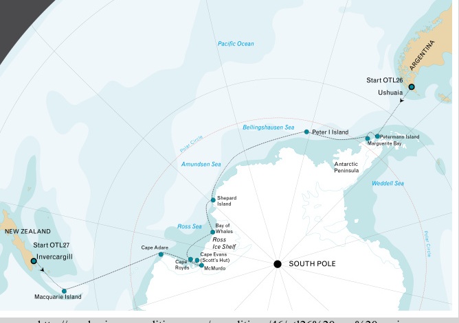
source: http://newhorizonexpeditions.com/expeditions/46/otl26%20ross%20sea.jpg
http://newhorizonexpeditions.com
TRIP ITINERARY AS ADVERTISED -- if it's real (which I haven't yet determined).
Visiting
Ushuaia, Argentina - Antarctic Peninsula - Peter I Island - Ross Ice Shelf - Macquarie Island - Invercargill (New Zealand)
Highlights
•Landings by helicopter during voyage*
•The wildlife of the Antarctic Peninsula, Amundsen & Ross Sea areas.
•Stunning scenery, icebergs and glaciers.
•Ross Ice Shelf.
•Cape Evans with the cabin of Robert Falcon Scott.
•Visit US-station McMurdo and Scott Base (New Zealand).
•Campbell Island.
Wildlife
•Seabirds: Albatrosses, Fulmars, Petrels, Shags, Skuas, Prions, Shearwaters.
•Penguins: Chinstrap, Gentoo, Adelies, Emperor, Royal.
•Whales: Humpback, Fin, Minke, Orca, Southern Right, Blue, Sperm, Dolphins.
•Seals: Weddell, Crabeater, Fur, Elephant & Leopard.
Duration
•31 nights/32 days
Detailed Itinerary
Please note: Two voyages are available - Voyage NHO26 offers the same itinerary as voyage NHO25, but in reverse.
A true Discovery voyage including the southern Antarctic Peninsula, the rarely visited volcanic Peter I Island, exploratory program along the outer fringes of the pack-ice in the Amundsen sea, Roald Amundsen's starting point from where he gained access to the ice-shelf and finally reached the South Pole in 1911, sailing voyage in the Ross sea, the huts of British explorers Ernest Shackleton and Robert Falcon Scott, Mc Murdo Station, the Dry Valleys and Macquarie Island - Welcome aboard one of the most spectacular expeditions on our planet
*Helicopter transfers:
During these voyages we will transfer our passengers ashore by zodiac. There will also be two helicopters availalbe in the event that zodiacs can not be used. Potential candidates for helicopter transfers are Peter I Island, The Ross Ice-shelf, the Dry Valleys, Mc Murdo Station, Cape Evans (hut of Scott) and Cape Royds (hut of Shackleton). In theory we plan on five helicopter based landings, but a specific amount of helicopter time can not be predicted. The use of helicopters is a great advantage and can support in the goal to reach certain landing sites, that otherwise are almost inaccessible.
But, this is a true expedition and we operate our itinerary in the world's most remote area, ruled by the forces of nature, weather and ice conditions. Conditions may change rapidly, having its impact on helicopter operations and passengers should understand and accept this.
Safety is our greatest concern and no compromises can be made. No guarantees can be given and no claims will be accepted. The vessel is equipped with two helicopters, but in the case that one helicopter is unable to fly due to for example a technical failure, the helicopter operation will cease or even be cancelled, due to the fact that one helicopter always needs to be supported by a second operational helicopter. No guarantees can be given and in no event will claims be accepted.
Special note: crossing the Date Line:
Both NHO25 and NHO26 have a total duration of 31 nights / 32 days. However, looking at the starting and ending dates of the voyages, it "seems" that NHO25 has duration of 32 nights and NHO26 of 30 nights. This is explained by the fact that we cross the "date line" at 180 degrees longitude. Travelling on NHO25 and crossing the International Date Line, results in a day being added and on NHO26 results in a day being subtracted. In any case, the duration of the voyage is still 31 nights / 32 days for both voyages.
Please note: Voyage NHO26 offers the same itinerary as voyage NHO25, but in reverse.
Day 1
Ushuaia - In the afternoon, we embark in Ushuaia, Tierra del Fuego, Argentina, the southernmost city in the world located at the Beagle Channel and sail through this scenic waterway for the rest of the evening.
Voyage NHO26 starts in Invercargill, New Zealand and offers the same itinerary as described hereunder, but in reverse.
Day 2 & 3: at sea
Day 4:
We arrive in the Antarctic Peninsula and sail in the early morning through the spectacular Lemaire Channel and land on Pléneau Island, where Elephant Seals haul-out on the beaches. Gentoo Penguins, Kelp Gulls and South Polar Skuas are confirmed breeders. Pléneau Island was first charted by the French Antarctic Expedition of 1903-05 of Jean-Baptiste Charcot and was named after his expedition's photographer Paul Pléneau. We will also visit Petermann Island with colonies of Adélie and Gentoo Penguins and Imperial Cormorants (Blue-eyed Shags). Petermann island was named after the German geographer August Petermann who was a member of a German Expedition in 1873-74.
Day 5:
Sailing south through the Penola Strait, we cross the Polar Circle and arrive at the Fish Islands. The small islands lying east of Flouder Island are called the Minnows, first charted by the British Graham Land Expedition (1934-37) of John Rymill. Detaille Island was discovered by the French expedition of Charcot (1903-05) and named for a share holder in the Magellan Whaling Company. From 1956 till 1959, The British Antarctic Survey had their "Station W" located on Detaille Island. On both locations we may observe Adélie Penguins and Blue-eyed Shags.
Day 6 - 7:
Bellingshausen Sea, where we may see our first pack-ice.
Day 8:
Peter I Island or in Norwegian Peter I Øy is an uninhabited volcanic island (19 kilometres long ) in the Bellingshausen Sea. It was discovered by Fabian von Bellingshausen in 1821 and was named after the Russian Tsar Peter I. It is claimed by Norway and considered a territory by its own. It is sporadically visited by passenger vessels.
Day 9 - 14:
These days we sail through the Amundsen Sea along and through the outer fringes of the pack-ice, which - depending of ice-conditions - will give us glimpses of the Antarctic Continent, while we take advantage of the west-going Antarctic coastal current.
The sailing along and through the ice is very lively, with sightings of single straggling Emperor Penguins, groups of seals on ice-floes, and also Orca's and Minke Whales along the ice-edge, often accompanied by different species of fulmar petrels.
If the sea-ice allows, we will try to land on Shephard Island in Marie Byrd Land among colonies of Chinstrap Penguins and South Polar Skua's. Shephard Island was discovered by the US Antarctic Expeditions (USAS) of 1939-41 and was named after one of the promoters of this expedition: John Shephard.
Day 15:
We approach the Ross Ice Shelf, a floating mass of land-ice, with a front of 30 meters high. In the Bay of Whales at the eastern side of the shelf, close to Roosevelt Island (named by the American aviator Richard E. Byrd in 1934 for President Franklin D. Roosevelt), Roald Amundsen gained access to the Shelf and ventured to the South Pole, where he finally arrived on 14 December 1911. For us it is perhaps a chance to climb on the shelf as well.
Day 16:
Along the Ross Ice Shelf we sail to the west.
Day 17 - 21:
In the Ross Sea we will visit Ross Island, guarded by Mount Erebus, Mount Terror and Mount Bird with all the famous spots which played such an important role in the dramatic British expeditions of the last century such as Cape Royds with the cabin of Ernest Shackleton. If ice-conditions are favourable, we will also visit Cape Evans with the cabin of Robert Falcon Scott; from Hut Point Scott and his men set out for the South Pole. We will further make attempts to visit the US-station McMurdo and Scott Base (New Zealand).
From Castle Rock we will have a great view across the Ross Ice Shelf toward the South Pole. We will have a view into Taylor Valley, one of the Dry valleys, where on our planet you are closest to the conditions on Mars. For the Dry Valleys we plan to use our helicopters. This is just one example of helicopter use during this epic voyage.
Day 22 - 23:
Sailing northward along the eastern west coast of the Ross Sea ,we pass by the Drygalski Ice Tongue and the Italian Station in Terra Nova Bay and further cape Hallet.
Day 24:
Cape Adare is the place where people for the very first time wintered on the Antarctic Continent. The hut where the Norwegian Borchgrevink stayed in 1899, is surrounded by the largest colony of Adélie Penguins in the World.
Day 25: at sea.
Day 26:
We sail along Scott Island.
Day 27 - 29: at sea.
At sea towards Campbell Island.
Day 30:
Campbell Island is a sub-Antarctic New Zealand Reserve and an Unesco World Heritage Site, with a luxuriant and blooming vegetation. The fauna on Campbell Island is fantastic with a large and easily accessible colony of Southern Royal Albatrosses on the main island and breeding Wandering, Campbell, Greyheaded, Blackbrowed, and Lightmantled Sooty Albatrosses on the satellite islands. Also three penguin species, Eastern Rockhopper, Erect-Crested and Yellow-Eyed Penguins breed here. In the 18th century seals were hunted to extinction, but Elephant Seals, Fur Seals and Sea Lions have recovered.
Day 31: at sea.
Day 32:
We arrive in Bluff near Invercargill (New Zealand) where passengers depart for their homebound journey. Voyage OTL26 ends in Ushuaia, Argentina and starts in Bluff, near Invercargill and offers the same itinerary as described above, but in reverse.
↧
Circumnavigation by Carnegie in 1916 took 4 months but was well north of 60S.
You can see that the route of the Carnegie never goes higher than 60S latitude. You can see for yourself that there are significant "short cuts' being taken by the ship as seen in the pointed peaks of the dark line in the map below. On an azimuthal flat earth projection, those will be clearly seen as shortening the trip considerably.
![]()
![]()
Notice that Antarctica is not completely outlined below. Note too that above 60S, the distance on an azimuthal projection increases considerably. It's quite concievable that if the short-cut routes of the Carnegie took 4 months-- that a non-short-cut-above-60S route (around 75S) -- would have taken much longer. My inaccurate sketch of that projection doesn't quite make that clear but you can at least see the problem we're faced with. More accurate maps can certainly be made... I'm just proposing a direction of research.
Here's are links to stories about the Carnegie's voyages, including this Antarctica one.
https://library.gl.ciw.edu/ocean/carnegie/main.html
http://publicationsonline.carnegiescience.edu/legacy/exhibits/ault_exhibition/antarctica.html

I created the following map quickly in 5 minutes by eyeballing alone. It's not accurate but it's a starting point. You can see there's a big difference between the yellow line, the voyage as close as I could get it in 5 minutes, vs. that orange line which goes along Antarctica's coast. I guess we would have to capture the ship's logs and their latitude and longitude estimates-- and how they got those numbers-- a century ago. It's typical of many if not all of the circumnavigations of Antarctica I've seen involve latitudes that are too high for satisfying my curiosity about the true distance around Antarctica-- and the Carnegie is just another one-- albeit a bit more interesting than, say, the Vendee Races or individuals doing yacht trips around the southern oceans.

↧
Measuring speed on water and in the air become a major problem for me.
Measuring speed on water and in the air become a major problem for me.
I've been considering the problem of the distance around Antarctica as a way to verify a flat vs. a spherical earth for about a year now. Not once, in that time, have I really thought about how speed is measured-- on water or air. I'm familiar enough and trusting enough of the odometer in my car that I don't worry about land speed. It's speed over water and air that has me vexed now. I see all sorts of analyses and technical ways of understanding it when I do a search but frankly, I'm not grasping it as fully as I need to. It's a loose end. Without it, this mission is doomed.
As a recent post I wrote began sinking in-- the one about the stupid computerized buoy's "they" are placing all over the world's oceans-- THOUSANDS upons THOUSANDS of them-- (financed by who again?)-- I started wondering exactly HOW they determined that a buoy would help determine that the speed of the ANTARCTIC CIRCUMNAVIGATION CURRENT (with it's own acronym ACC)-- was determined to be 1 knot or... in other articles I've seen 5 knots. NOTE that the difference is of an order of magnitude that could be the difference between a 15,000 vs. a 60,000 mile coast line for Antarctica. How convenient for "them" that there is "mass confusion" over this issue and that it's likely that not one-in-ten-million-people knows how to compute speed over water and air, either with ancient "old fashioned" methods nor modern "lying" GSP (which is NOT based on satellites-- which don't exist).
I'm weary already. I'll continue to construct this entry over coming days. Right now, I have to tend to chores... the chores of a slave-human.
The following video will be turned into a youtube playlist in coming days and weeks as I learn more about how to measure distance in water and air. It turns out that I'm going to have to dig into this to be able to confirm or deny the distances various people are claiming is the distance around Antarctica. Join me in watching these videos as I teach myself how to navigate so we can understand the true distance around Antarctica-- and what to watch for if we watch others going around Antarctica.
The following video will be turned into a youtube playlist in coming days and weeks as I learn more about how to measure distance in water and air. It turns out that I'm going to have to dig into this to be able to confirm or deny the distances various people are claiming is the distance around Antarctica. Join me in watching these videos as I teach myself how to navigate so we can understand the true distance around Antarctica-- and what to watch for if we watch others going around Antarctica.
↧
↧
If we're going to circumnavigate Antarctica by air or sea, we should check the weather but there's a problem.
Apparently, we can't check the weather in Antarctica. (Apologies in advance for the low volume and expletives used by the creator of the video which is interesting nonethe less.)
↧
Jungle Surfer predicts NASA will do a circumnavigation.
↧
Quick Google-maps video tour of about 27 of 80 claimed research stations with map correlation
The following video claims that there are 80 stations. I'll have to look at the Wikipedia entry on stations again as well as other maps. The concept of the video is interesting-- I've posted it in this blog before. Today, however, I have a better understanding of the various stations and travel between them as well as fuel depots, GPS stations, and other aspects of Antarctica so it's interesting to revisit this approach.
Below the video is the first map I chose to correlate what is shown in the video with the standard map of Antarctica's research stations with clear latitude and longitude lines. As the video plays, you can scroll down quick to see where the station is, then scroll back up. Stop the video if you like to really get a lock on where you are, on the map.
There's more to be done in this post because there are stations mentioned in the video that I do NOT see on the up-to-date map below but again-- the concept is very good. Certainly the Google earth view can be used to detect convexity vs. concavity as well-- which should correspond to Antarctica as a rim or island but the video doesn't really make that as clear as I'd like. It appears convex, consistent with an island but the photos are arrayed pieces like a puzzle so manipulation is possible and likely. Anyway, I'll review the following video again and post updates below as I'm able to.![]()
Below the video is the first map I chose to correlate what is shown in the video with the standard map of Antarctica's research stations with clear latitude and longitude lines. As the video plays, you can scroll down quick to see where the station is, then scroll back up. Stop the video if you like to really get a lock on where you are, on the map.
There's more to be done in this post because there are stations mentioned in the video that I do NOT see on the up-to-date map below but again-- the concept is very good. Certainly the Google earth view can be used to detect convexity vs. concavity as well-- which should correspond to Antarctica as a rim or island but the video doesn't really make that as clear as I'd like. It appears convex, consistent with an island but the photos are arrayed pieces like a puzzle so manipulation is possible and likely. Anyway, I'll review the following video again and post updates below as I'm able to.

↧